
Here is the full blog, ready to copy and paste:
From Art to Infrastructure: How AI Is Reframing Landscapes as Living Systems
For homeowners, property managers & strata in Greater Victoria and Vancouver Island | Zone 9b
Quick Answer: Your landscape can do far more than look good. With AI-assisted planning, it can manage stormwater, lower surface temperatures, and capture carbon — all while staying beautiful. For homeowners and strata across Greater Victoria and Vancouver Island, that means fewer flooding events, lower cooling costs, and landscapes built to meet today’s climate expectations and CRD bylaws.
Most homeowners think of their yard as a visual feature — something to impress guests and provide a place to relax. That’s still true. But a quiet shift is changing how landscape professionals design outdoor spaces. AI is helping us see landscapes as infrastructure: systems that manage water, regulate heat, and sequester carbon, just like roads, pipes, and buildings do.
On Vancouver Island, this shift is especially relevant. Victoria sits in Zone 9b — a mild, wet-winter, dry-summer climate with clay-heavy soil, increasingly hot summers, strict CRD watering rules, and a growing wildfire interface. Our landscapes face real pressure. AI gives designers the data to respond effectively.
This blog explains exactly how AI-assisted landscape planning works — and what it means for your property in Greater Victoria.
1. What Does “AI in Landscaping” Actually Mean?
What It Is
AI in landscaping means using data-analysis tools — satellite imagery, weather models, soil databases, and site sensors — to make smarter decisions about how a property should be designed and managed. It is not robots mowing lawns. It is better information, delivered faster.
Why It Matters
Traditional landscape design relies on a designer’s experience and a site visit. Those still matter enormously. But AI adds a data layer no human can process alone: real-time rainfall rates, surface temperature maps, soil permeability scores, tree canopy gap analysis. Designs become evidence-based, not just instinct-driven.
IslandEarth Example
When IslandEarth evaluates a strata property in Saanich, the team uses satellite-based canopy analysis to pinpoint heat pockets — areas where concrete or south-facing slopes run 8–12°C hotter than surrounding zones on a July afternoon. That data shapes exactly where shade trees go. Not a guess — a calculation.
📸 Image alt-text 1: “IslandEarth landscape designer reviewing AI-generated canopy gap analysis map for Saanich strata property — Greater Victoria Zone 9b”
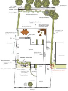
2. Stormwater Management: When Rain Becomes an Asset
What It Is
Stormwater management means designing your landscape to absorb, slow, or redirect rainfall — rather than letting it run off into storm drains, foundations, or neighbouring lots. Key features include bioswales, rain gardens, permeable paving, and strategic native plantings.
Why It Matters in Victoria
Greater Victoria receives 600–900 mm of rain annually — most of it falling between October and March. Clay soils common across Saanich, Esquimalt, and Colwood drain poorly. The City of Victoria and CRD both have stormwater management guidelines that increasingly hold property owners responsible for runoff leaving their site. Poor drainage causes basement flooding, slope erosion, and nutrient runoff into local waterways and sensitive coastal ecosystems.
AI modelling shows exactly where water pools, how fast it moves across different surfaces, and which interventions reduce peak runoff most effectively. Instead of guessing where to put a swale, designers can calculate it.
IslandEarth Example
On a Langford property with chronic winter puddling near the carport, IslandEarth used rainfall and slope-data modelling to position a planted bioswale along the low side of the driveway. The feature handles 85% of normal winter events without overflow — and it’s planted with native sedges and rushes that look intentional, not remedial.
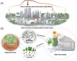
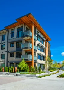
3. Heat Mitigation: Keeping Vancouver Island Cool
What It Is
Heat mitigation in landscaping means designing outdoor spaces that lower surface temperatures — shading hard surfaces, increasing vegetation cover, and reducing the urban heat island effect where pavement and buildings trap warmth.
Why It Matters Locally
The June/July 2021 heat dome showed British Columbia that extreme heat is a real, recurring risk. Victoria’s urban neighbourhoods — especially those with dense asphalt and south-facing lots — saw surface temperatures climb far above air temperature readings. The BC government and local municipalities are now actively promoting urban cooling strategies through tree canopy targets and green infrastructure requirements.
AI-powered thermal imaging and canopy analysis identify which specific zones on a property need shade most urgently. That means the right tree in the right spot — not a guess.
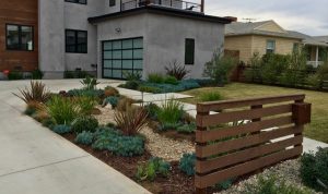
IslandEarth Example
For a strata complex in View Royal, IslandEarth used satellite surface-temperature data to identify that the south-facing visitor parking area was peaking at 52°C on hot days. Three large canopy trees were planted on the southwest edge of the lot. Projected surface temperature reduction in that zone: 9–11°C within eight years as the canopy matures.
📸 Image alt-text 2: “Mature canopy trees shading south-facing residential parking area on Vancouver Island — IslandEarth heat mitigation design, Zone 9b Greater Victoria”
4. Carbon Capture: Your Landscape as a Climate Tool
What It Is
Plants absorb CO₂ as they grow. Soil stores carbon too — especially when it’s rich in organic matter. A landscape designed for carbon capture maximizes both: dense plantings, deep-rooted native species, and soil management practices that build organic content rather than depleting it.
Why It Matters
The BC government’s CleanBC Roadmap to 2030 commits to measurable carbon reduction across all sectors. The City of Victoria and District of Saanich have their own climate action targets. Strata boards and property managers are increasingly asked to demonstrate environmental responsibility — and AI tools turn vague “green” intentions into documented, measurable outcomes.
AI platforms can estimate how much carbon a given plant species will sequester over 10, 20, and 50 years. Paired with periodic soil testing, they can also track soil carbon trends over time.
IslandEarth Example
When IslandEarth replaced a 400 sq ft lawn with a mixed native garden bed at a Saanich residence, species-sequestration modelling guided the plant selection. The bed is projected to capture an estimated 2.1 tonnes of CO₂ over 25 years — roughly equivalent to taking one car off the road for two years. From a single backyard bed.

5. Smart Irrigation: Meeting CRD Watering Rules with Data
What It Is
Smart irrigation uses evapotranspiration (ET) data — a measure of how much water plants actually need based on temperature, humidity, wind, and solar radiation — to schedule watering automatically. AI-driven controllers adjust daily based on real weather, not fixed timers.
Why It Matters in Victoria
The CRD enforces Stage 1, 2, and 3 watering restrictions during dry summers. Stage 2 is common by July. Violations carry fines, and poorly timed irrigation wastes water while stressing plants. ET-based systems cut outdoor water use by 20–50% compared to timer systems — while keeping plants healthier because they’re watered when actually needed.
IslandEarth Example
IslandEarth upgraded an older timer-based irrigation system at an Oak Bay strata to a smart ET controller. First summer results: 34% reduction in water use, zero watering violations during Stage 2 restrictions, and the lawn stayed green into August without any supplemental hand-watering.

6. Biodiversity: Landscapes That Support Local Ecosystems
What It Is
Biodiversity in landscape design means selecting plants and layouts that support pollinators, birds, and soil organisms — not just visual appeal. AI tools can map pollinator corridors, score habitat quality, and recommend native species combinations suited to each microclimate.
Why It Matters Locally
Vancouver Island hosts globally significant ecosystems, including Garry oak meadows — one of the rarest habitat types in Canada. The Species at Risk Act (SARA) protects several species associated with these ecosystems. BC’s biodiversity strategy encourages private landowners to contribute to ecological connectivity. The plants you choose genuinely matter beyond your property line.
IslandEarth Example
On a North Saanich acreage, IslandEarth used pollinator corridor mapping to design a 120-metre native hedgerow connecting two remnant Garry oak stands. Species selection — camas, blue-eyed Mary, nootka rose, red-osier dogwood — was guided by habitat scoring software. The hedgerow now supports three native bee species not previously documented on the property.
📸 Image alt-text 3: “Native pollinator hedgerow in North Saanich connecting Garry oak stands with camas and nootka rose plantings — IslandEarth biodiversity landscape design, Vancouver Island”
7. Soil Health: The Foundation AI Helps You See
What It Is
Healthy soil is the starting point for every functional landscape. AI tools help track compaction, organic matter levels, pH, and drainage over time — making it easier to intervene before problems become expensive.
Why It Matters in Victoria
Victoria’s clay soils are notoriously difficult. They drain slowly, compact under foot and vehicle traffic, and swing between waterlogged in winter and bone-hard in summer. Without good soil data, landscape improvements are often temporary fixes that don’t address root causes — literally.
IslandEarth Example
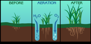
Before redesigning a problem lawn in Colwood, IslandEarth ran a soil permeability assessment using probe data and moisture mapping. Results revealed two distinct compaction zones from historic vehicle use. The design routed drainage around those zones and used targeted aeration and topdressing to rehabilitate them — avoiding the cost of full soil replacement.
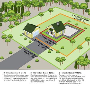
8. FireSmart Design: Where Beauty Meets Risk Reduction
What It Is
FireSmart BC guidelines recommend plant choices and spacing that reduce wildfire risk in wildland-urban interface (WUI) zones. AI can map fire risk across a property and score existing plantings against FireSmart criteria, identifying problem species before fire season.
Why It Matters on Vancouver Island
Parts of Vancouver Island — including areas near Langford, Highlands, and North Saanich — sit within or adjacent to WUI zones. FireSmart BC recommends a defensible space with low-flammability plants within 10 metres of any home. AI-based risk mapping identifies high-risk planting clusters and suggests compliant alternatives that still look good year-round.
IslandEarth Example
On a Highlands acreage, IslandEarth used FireSmart BC plant lists combined with proximity mapping to replace a dense juniper hedge (high flammability) with spaced plantings of kinnikinnick, Oregon grape, and red fescue — all native, low-flammability, and visually appealing through all four seasons.
9. Strata & Property Management: AI Makes the Business Case Clearer
What It Is
For strata corporations and commercial property managers, AI-assisted planning provides something especially valuable: documentation. Data-backed designs make it easier to justify capital expenditure to strata councils, demonstrate bylaw compliance, and benchmark landscape performance year over year.
Why It Matters
Strata councils face growing pressure from owners to demonstrate responsible stewardship — of water, budgets, and long-term property value. A landscape that demonstrably reduces stormwater runoff, lowers irrigation costs, and improves biodiversity is far easier to defend at an AGM than one chosen purely for aesthetics.
IslandEarth Example
IslandEarth worked with a 42-unit strata in Esquimalt to develop a 5-year landscape infrastructure plan with projected water savings, stormwater compliance metrics, and canopy coverage targets. The plan was approved unanimously at the AGM — because the numbers made the case. No debate required.
10. What This Means for Your Property Right Now
What It Is
You don’t need to redesign your entire property to start treating it as infrastructure. Small, targeted changes add up to real functional gains — and they often cost less than reacting to flooding, heat damage, or failed plantings after the fact.
Why It Matters
The City of Victoria, District of Saanich, and other CRD municipalities are moving toward stronger landscape and stormwater bylaws. Properties that already function as infrastructure will be ahead of those requirements — and more resilient to the wet winters and dry summers that define our Island climate.
IslandEarth Example
A homeowner in Gordon Head contacted IslandEarth after their backyard flooded three consecutive winters. The solution required no major construction: a reconfigured downspout directed to a new rain garden, one large native tree on the wet side of the yard, and a permeable gravel path replacing 40 sq ft of concrete. Problem solved. Total cost: under $4,000.
AI-Optimized Landscape Functions: Quick Reference for Victoria Properties
| Landscape Function | What AI Optimizes | Victoria / Island Benefit |
|---|---|---|
| Stormwater Management | Runoff modelling, bioswale sizing, soil permeability mapping | CRD stormwater compliance, flood risk reduction, clay soil drainage |
| Heat Mitigation | Surface temp mapping, canopy gap analysis, shade placement | Urban heat island reduction, wildfire buffer, cooling-cost savings |
| Carbon Capture | Species sequestration rates, biomass estimates, soil carbon | CleanBC targets, Saanich/Victoria sustainability commitments |
| Smart Irrigation | ET-based scheduling, leak detection, zone performance scoring | CRD Stage watering compliance, 20–50% water savings |
| Biodiversity Support | Pollinator corridor mapping, native species suitability | Garry oak ecosystem, Species at Risk Act awareness |
| Soil Health | Compaction mapping, pH & organic-matter trending | Fixing Victoria clay, long-term drainage without full regrading |
| FireSmart Planning | Flammability scoring, WUI proximity mapping, plant-list match | Langford / Highlands / North Saanich wildland-interface zones |
Mini FAQ: AI and Landscape Infrastructure on Vancouver Island
Is AI landscaping only for large or commercial properties? No. AI tools are increasingly accessible at the residential scale. IslandEarth uses data-driven analysis for individual homes, strata complexes, and estates across Greater Victoria.
Does AI replace a landscape designer? No. AI surfaces data patterns. Your IslandEarth designer interprets those patterns and builds a real-world plan that fits your site, your budget, and local conditions.
Will an infrastructure-focused landscape still look good? Yes. Bioswales look like naturalistic gardens. Shade trees are naturally beautiful. Carbon-capture plantings often feature flowering native species. Functional and attractive are not opposites.
How does AI help with CRD watering restrictions? ET-based irrigation controllers water plants only when they actually need it — cutting use by 20–50% versus timer systems, while keeping you compliant with CRD Stage 1, 2, and 3 rules.
What data does AI use for my specific property? Satellite imagery, local weather records, municipal soil-type maps, stormwater models, and site photos. No invasive sensors are required for an initial analysis.
Quick Checklist: Make Your Landscape Work Harder
- ☐ Ask your landscape contractor if they use data-driven or AI-assisted site analysis
- ☐ Request a stormwater assessment for any property with recurring drainage problems
- ☐ Confirm your irrigation system uses ET-based (smart) scheduling — not fixed timers
- ☐ Add at least 3 native species per 100 sq ft to support pollinators and soil carbon
- ☐ Replace at least one impermeable hardscape zone with permeable pavers or gravel
- ☐ Plant one large canopy tree per 500 sq ft of south- or west-facing surface to cut heat
- ☐ Commission a soil permeability check before any major planting or drainage upgrade
- ☐ Verify your irrigation schedule is CRD Stage-watering-compliant before each summer
- ☐ Identify one low-lying area that could function as a bioswale or rain garden
- ☐ Cross-reference existing plantings against FireSmart BC lists if near a WUI zone
Summary
Your landscape is not just a place to look at — it’s a working system that can manage water, cool your property, capture carbon, and support local wildlife, all at once. AI-assisted landscape planning gives designers better data to make those systems perform reliably, without sacrificing how your yard looks or feels. For homeowners and strata across Greater Victoria and Vancouver Island, this means landscapes that are more resilient to our wet winters and dry summers, more aligned with CRD and municipal guidelines, and more defensible as a long-term investment. The shift from art to infrastructure is not about losing beauty — it’s about your landscape doing more of the heavy lifting, quietly and effectively, all year long.