
When landscaping, having precise and comprehensive data about the site is crucial for effective planning and execution. Enter laser scanning technology, a game-changer for site analysis that offers detailed topographical data for large landscape areas. This blog explores how laser scanning works, its benefits, real-world applications, and its future potential, all in a way that’s accessible and useful for gardeners and landscapers alike.

What is Laser Scanning?
Laser scanning, also known as LiDAR (Light Detection and Ranging), involves using laser beams to measure distances to the earth. These measurements are used to create highly accurate 3D models of the terrain. The process consists of emitting laser pulses and measuring the time it takes for them to bounce back from the surface. This data is then processed to generate detailed topographical maps.

Benefits of Laser Scanning
- Accuracy and Detail: Laser scanning can capture minute details of the landscape, including subtle variations in elevation and surface features, which are often missed by traditional surveying methods.
- Efficiency: Traditional surveying can be time-consuming and labour-intensive. Laser scanning can cover large areas quickly and with fewer personnel.
- Cost-Effective: While the initial investment in laser scanning equipment can be high, the technology can save money in the long run by reducing labour costs and increasing the speed of data collection.
- Safety: Laser scanning allows for data collection from a distance, reducing the need for surveyors to navigate rugged or hazardous terrain.

Real-World Applications
Residential Gardens: Laser scanning can provide a detailed property map for homeowners planning extensive landscaping projects. This helps design features like terraces, retaining walls, and water features that fit perfectly with the land’s natural contours.
Parks: Managing large public parks requires precise knowledge of the terrain. Laser scanning can help park managers plan trails, manage erosion, and design new recreational areas that blend seamlessly with the natural environment.
Commercial Properties: For commercial landscapes, where precision is critical to aesthetics and functionality, laser scanning ensures that every element, from pathways to planting beds, is perfectly placed.

Compared with Traditional Methods
Traditional surveying methods typically involve manual measurements and GPS devices. While these methods can be effective, they often need more precision and comprehensiveness than laser scanning. For example, manual surveying might miss small dips or rises in the terrain that can affect drainage or plant growth. Laser scanning captures these details, providing a more complete picture.
Recommended Equipment and Software
Several companies offer laser scanning equipment tailored for landscaping use. Some popular options include:
- Trimble X7: Known for its user-friendly interface and precise data capture.
- Leica BLK360 is an excellent compact and portable scanner for smaller projects.
- FARO FocusS: It offers high accuracy and range and is suitable for more significant landscapes.
On the software side, tools like Autodesk ReCap and Trimble RealWorks can help process and analyze the scanned data, making it easier to integrate into your landscape designs.
Future Potential and Advancements
The future of laser scanning in landscaping looks bright, with advancements to make the technology even more accessible and efficient. Emerging trends include:
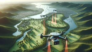
- Integration with Drones: Drones equipped with laser scanners can cover even larger areas and hard-to-reach places, providing comprehensive data without human intervention.
- Real-Time Processing: Advances in software are making it possible to process and analyze data in real-time, speeding up the decision-making process.
- Enhanced Precision: Ongoing improvements in laser technology are leading to even greater accuracy, capturing the most minor details of the terrain.
Conclusion
Laser scanning technology revolutionizes site analysis for gardeners and landscapers, offering unparalleled detail and efficiency. Providing accurate topographical data allows for more precise planning and design, ultimately leading to more beautiful and functional landscapes. As the technology evolves, its applications will only expand, opening up new possibilities for landscape professionals.
So, consider incorporating laser scanning into your toolkit, whether planning a small garden makeover or managing a large public park. It’s an investment in accuracy, efficiency, and, ultimately, the success of your landscaping projects.